Radar Optimized Wind Turbine Siting
The Radar-Optimized Wind Turbine Siting (ROWTS) technique calculates where to locate wind turbines such that they present minimal interference to the performance of radar systems. Published as open-source software, ROWTS is an aid to builders of wind farms, enabling them to plan a site layout that decreases impacts to radar systems, allows space for the desired density of turbines, and circumvents obstructions such as buildings, roads, and rivers. ROWTS capabilities could help streamline the roll-out of wind-powered energy infrastructure.
Motivation
The current emphasis on renewable energy options has spurred the development of wind farms. Yet, concerns about the wind turbines' impact on critical radar systems, such as weather and air traffic control radars, often inhibit wind farm construction. The turbines, which strongly reflect electromagnetic waves, are seen by radar systems as large objects, but the turbines' fast rotation speed renders ineffective the Doppler processing that radars typically use to avoid interference caused by objects like tall structures or mountains.
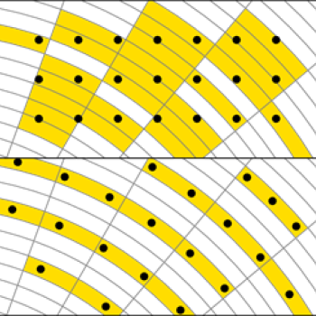
The top image at left illustrates that when wind turbines (black dots) are aligned in a grid randomly with respect to radar systems, a large fraction of the radar’s coverage over the wind farm can be impeded (yellow). But, as seen in the bottom image, by aligning the wind turbines relative to the radar systems, clear area (white cells) can be opened between wind turbines to restore radar coverage.
Solution
The ROWTS software plots a grid for locating wind turbines to lessen the interference (or clutter) they produce to radar transmissions. The placement of the wind turbines is staggered such that the regions "contaminated" by turbine-induced clutter overlap, thereby minimizing the total area contaminated.
Combining this staggered siting with the industry-standard practice of tuning radar systems near wind farms to be desensitized to turbine-induced clutter, ROWTS optimizes the land area required for the farm. By enabling developers to deploy a desired number of turbines on a land footprint smaller than that achieved by traditional site plans, ROWTS decreases the purchase costs of the necessary acreage and increases the likelihood of finding a large enough site with potentially low impact to radars. The prudent use of land while preserving radar performance may prevent delays in or denials to permits for wind farm construction.
Benefits
- ROWTS recommendations achieve the same density of turbines as industry-standard practices achieve for a wind farm
- Decreased impact on radar systems may facilitate a speedy and modification-free permitting process
- ROWTS keeps down costs because its interference-mitigation strategy maintains wind turbine density without requiring the acquisition of additional land
Additional Resources
This software is available at https://github.com/mit-ll/wt-siting
D.J. Brigada and J. Ryvkina, "Radar-Optimized Wind Turbine Siting," IEEE Transactions on Sustainable Energy, vol.13, no. 1, January 2022.