
Active Optical Systems
We conduct R&D in advanced electro-optical and infrared sensors used in intelligence, surveillance, and reconnaissance (ISR) and tactical missions. We focus on developing field-deployable active and passive imaging and remote-sensing systems. Our operational three-dimensional imaging laser radars (ladars) employ unique large-format, high-bandwidth detector arrays that are sensitive to single photons and are capable of rapidly mapping city-scale areas at very high resolution. We develop advanced algorithms and employ computer-vision techniques to perform automated scene interpretation. We are also developing coherent laser radar, exploring the adaptation of advanced radar techniques to the optical wavelengths and pushing the bandwidth of coherent systems to the terahertz scale. Another significant research area in our group is the development of advanced passive receivers that are based on high-bandwidth digital focal plane arrays capable of on-chip processing. We perform systems analysis to formulate mission-specific sensor concepts and conduct experiments to validate those concepts. We also perform data collection campaigns to investigate new phenomena and develop novel sensing modalities based on these data. Our goal is to develop and deliver advanced optical systems that enable high-impact capabilities for the nation.
Featured Projects

lidar
Finding People Under the Rainforest Roof with Lidar
Lincoln Laboratory is exploring the feasibility of building an airborne sensing system to detect the presence of humans under dense tree canopy.
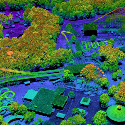
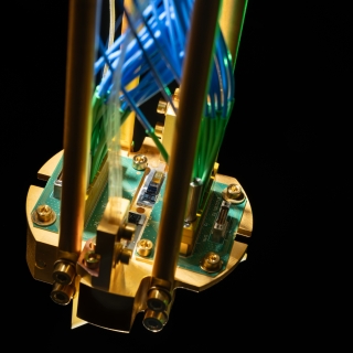
ladar
PHOENIX High CASTLE
We developed a ladar that samples at the diffraction limit to collect high-resolution imagery for geospatial mapping missions.

disaster relief
Seismic-Metamaterial Cloaking to Protect Infrastructure
Novel metamaterials deployed to provide a barrier around critical structures are designed to redirect and attenuate hazardous seismic waves.

optical systems
Micro-ladar
Recent advances in imaging architectures and real-time processing are enabling the development of a miniature ladar sensor that can be deployed on a UAV.
Latest News


Laboratory Stories
We do real-world, goal-oriented projects but with academic curiosity and depth of understanding.
Emily Peterson
Lidar Sensor Designer
ISR Systems and Technology
Active Optical Systems

I believe noninvasive brain stimulation is the future of many therapies, providing an alternative to the global effects certain medications have on the body and the risks posed by more invasive, surgical solutions.
Rebecca Laher
Algorithm Developer and Signals Researcher
ISR Systems and Technology
Active Optical Systems

I am proud and excited to represent Latinas in STEM.
Rebecca Venegas
Electro-Optical Engineer/Scientist
ISR Systems and Technology
Active Optical Systems

Software development has been a catalyst for me being able to learn about different science topics and make things work in the real world.
Diego Rivera
Software Engineer
ISR Systems and Technology
Active Optical Systems

Advancing Our Research
Featured Publications
Seismic barrier protection of critical infrastructure
Apr 25
16th Annual IEEE Int. Symp. on Technologies for Homeland Security, HST 2017, 25-26 April 2017.
Optical phased-array ladar
Nov 1
Appl. Opt., Vol. 53, No. 31, 1 November 2014, pp. 7551-5.

