Projects
![A small sensor being adapted for the methane-detecting network](/sites/default/files/styles/list/public/project/image/2024-12/test%20chamber%20v2.jpg?itok=i5LFOrc8)
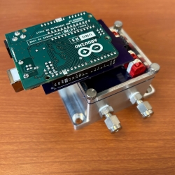
Low-Cost Methane Sensor Network
Deploying large networks of ground-based methane detectors could help detect pipeline leaks, improve climate models, and regulate emission sources.
Tags
![an illustration showing earth from space, with a drone, graphs showing data collection, and improved models overlaid on top.](/sites/default/files/styles/list/public/project/image/2024-03/hydro-metrology.png?h=6ecbb600&itok=oVEwJ6XE)
Advanced Sensing for Hydrological Metrology
With Alabama A&M University, we are identifying opportunities to apply new remote sensing concepts to improve groundwater measurements and models. These models can inform decisions related to agriculture, land use, human health and wellness, and geopolitical stability.
Tags
![A screenshot over the florida panhandle and carribean, with dots in the ocean representing spare salinity monitors.](/sites/default/files/styles/list/public/project/image/2024-03/Salinity%20Profile.png?h=3184aa5c&itok=lMXh1FJq)
Compact Optical Salinity Sensor
We are developing a compact and encapsulated optical salinity sensor to enable more distributed and persistent monitoring of the ocean’s 3D structure.
Tags
![A map of the United States with areas colored on a scale from yellow to dark red, indicating drought severity.](/sites/default/files/styles/list/public/project/image/2024-03/Drought-map.png?itok=FzV1TKVT)
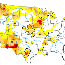
Artificial Intelligence–Based Drought Prediction
We are developing a neural network using data derived from satellite measurements of temperature and humidity to improve drought monitoring and forecasting.
Tags
![A photo of a hallway between two rows of data center servers. Two researchers are working on the servers.](/sites/default/files/styles/list/public/news/image/2023-09/525558-006D.jpg?itok=H9vnrix7)
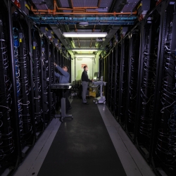
Green Instrumentation and Experimentation
We are innovating and accelerating solutions to address AI's carbon footprint and reduce data center energy usage.
Tags
![an illustration of Earth from space with two lidar-housing satellites orbiting near eachother.](/sites/default/files/styles/list/public/project/image/2022-04/Aull-no%20labels.png?h=9d71c5a3&itok=94jDD5S9)
Atmospheric Aerosol Characterization
We are designing a satellite-based lidar system to categorize aerosols in the atmosphere.
Tags
![A photo of a Google earth image of Bangladesh, with a heat map over it showing mostly red.](/sites/default/files/styles/list/public/project/image/2022-04/CREWSNET.png?h=be37ad46&itok=gBX2D1d5)
Climate Resilience Early Warning System Network
We are creating proactive, integrated decision -support tools and services that empower frontline communities to prepare for climate impacts and minimize losses.
Tags
![A graphic showing radar-like storm coverage over a Google map image of land, and red/yellow/green zones of predicated tornado path..](/sites/default/files/styles/list/public/project/image/2022-03/ITORPE-big.png?h=5d0c5926&itok=7JL1muD4)
Intelligent Tornado Prediction Engine
We compiled a massive open-source dataset to develop deep learning models capable of detecting and predicting tornadoes.
Tags
![A photo of an interferometer on a lab bench. A staff member is adjusting a part of it.](/sites/default/files/styles/list/public/project/image/2024-03/529056-009.jpg?h=b9f39ab2&itok=J9HBoC_g)
Methane Detection Study
We are investigating the use of novel imaging technologies for detecting and quantifying methane emissions in the atmosphere.
Tags
![A photo of Arctic sea ice fracturing into big chunks.](/sites/default/files/styles/list/public/news/image/2024-07/1_ice%20fracture_Mar%2018%202024_OIC24_0116.jpg?itok=qCeJVB_a)
Arctic Climate Change Detection Network
We are developing a sensor network to improve our understanding and monitoring of sea ice breakup in the rapidly changing Arctic region.
Tags