Projects
Tagged As
![A schematic showing the Earth with many satellite links.](/sites/default/files/styles/list/public/project/image/2024-10/satNetworkingStill.jpg?itok=A52Ffwwn)
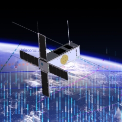
Networking for a New Era of Global Satellite Connectivity
Large constellations of satellites in low Earth orbit (LEO) allow for unparalleled global coverage but require new networking approaches.
Tags
![A schematic showing optical ground terminals and satellites transmitting data via lasercom links across the Earth and to the Moon.](/sites/default/files/styles/list/public/project/image/2024-05/Hollow-core%20fiber_1.jpg?itok=OTTfzbBV)
Guiding Light in Air-Filled Fibers for Long-Distance Lasercom
A new type of fiber could transmit the high-power light needed for future deep-space science and exploration missions.
Tags
![An illustration of data being sent across a laser from a small satellite to a ground station on Earth.](/sites/default/files/styles/list/public/news/image/2022-11/tbird_conops_public_notext.jpg?h=d1cb525d&itok=FFp50AcU)
TeraByte InfraRed Delivery (TBIRD)
The laser communications payload has delivered terabytes of data from a satellite to Earth at record-breaking rates that will transform future science missions.
Tags
![a photo of a small satellite in a studio](/sites/default/files/styles/list/public/project/image/2023-08/TROPICS.png?h=5463d0de&itok=1Rk-6x3n)
TROPICS
A constellation of small satellites is collecting rapidly refreshed weather data to advance studies of hurricane structure and intensity and improve forecasts.
Tags
![This image shows Mexico Beach, FL, after it sustained damage from Hurricane Michael in 2018. It was taken through NOAA’s Emergency Remote Sensing program. Satellites could provide similar information after more incidents. (Image courtesy of NOAA.)](/sites/default/files/styles/list/public/project/image/2022-09/DisasterSat%20image.jpg?itok=-mCu8dPb)
![an illustration of Earth from space with two lidar-housing satellites orbiting near eachother.](/sites/default/files/styles/list/public/project/image/2022-04/Aull-no%20labels.png?h=9d71c5a3&itok=94jDD5S9)
Atmospheric Aerosol Characterization
We are designing a satellite-based lidar system to categorize aerosols in the atmosphere.
Tags
![A photo of Arctic sea ice fracturing into big chunks.](/sites/default/files/styles/list/public/news/image/2024-07/1_ice%20fracture_Mar%2018%202024_OIC24_0116.jpg?itok=qCeJVB_a)
Arctic Climate Change Detection Network
We are developing a sensor network to improve our understanding and monitoring of sea ice breakup in the rapidly changing Arctic region.
Tags
![an illustration of satellite in space with Earth's blue surface in the background.](/sites/default/files/styles/list/public/project/image/2022-01/Cubesat.jpg?itok=6aMdT1qP)
Space Systems Cyber-Resiliency
We are researching and prototyping cyber-resilient space systems software that will enable critical national security space assets to withstand, operate through, and recover from cyberattack.
Tags
![Imagery from the GOES-16 Advanced Baseline Imager](/sites/default/files/styles/list/public/project/image/2019-06/earth-2.jpg?h=6c8fd2c3&itok=xM8bx9T1)
Geostationary Operational Environmental Satellite Series
The Laboratory's long-term collaboration with NOAA and NASA on environmental monitoring satellites has led to revolutionized weather imagery and products and improved detection for space and solar phenomena.
Tags
![Small satellites are an attractive option for missions because of their low costs; however, they are vulnerable to cyberattacks. We provide a securable and usable architecture for keeping small satellites resilient to system compromise.](/sites/default/files/styles/list/public/project/image/2019-06/Small_Sat_abstract%20_image_2.jpg?h=5cf53e86&itok=r4AQPhbV)
Secure Small Satellite Processing Platform
A secure reference architecture enables satellites to recover from cyberattacks and carry on their missions.
Tags