Projects
![a small electronic chip is illuminated with red laser light.](/sites/default/files/styles/list/public/project/image/2022-06/Atomic-clock.png?itok=pL1cHcWv)
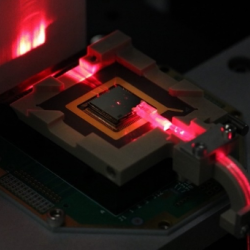
Compact Optical Trapped-Ion Array Clock
Optical atomic clocks are the most accurate in the world, but they are very large, sensitive instruments. We are transforming the complex components of these clocks into a compact, portable platform.
Tags
![A researcher stands on a laptop. In front of him are a few small radios, and a large projector screen showing data.](/sites/default/files/styles/list/public/news/image/2022-05/LLDARt.png?itok=Q3-ogmJC)
Low-Cost Localization Using Distributed Adaptable-Response Transponders
A deployable navigation network of small, low-cost radio transponders can help track the locations of first responders during rescue operations.
Tags
![A photo of a hallway between two rows of data center servers. Two researchers are working on the servers.](/sites/default/files/styles/list/public/news/image/2023-09/525558-006D.jpg?itok=H9vnrix7)
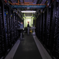
Green Instrumentation and Experimentation
We are innovating and accelerating solutions to address AI's carbon footprint and reduce data center energy usage.
Tags
![an illustration of Earth from space with two lidar-housing satellites orbiting near eachother.](/sites/default/files/styles/list/public/project/image/2022-04/Aull-no%20labels.png?h=9d71c5a3&itok=94jDD5S9)
Atmospheric Aerosol Characterization
We are designing a satellite-based lidar system to categorize aerosols in the atmosphere.
Tags
![A photo of a Google earth image of Bangladesh, with a heat map over it showing mostly red.](/sites/default/files/styles/list/public/project/image/2022-04/CREWSNET.png?h=be37ad46&itok=gBX2D1d5)
Climate Resilience Early Warning System Network
We are creating proactive, integrated decision -support tools and services that empower frontline communities to prepare for climate impacts and minimize losses.
Tags
![A graphic showing radar-like storm coverage over a Google map image of land, and red/yellow/green zones of predicated tornado path..](/sites/default/files/styles/list/public/project/image/2022-03/ITORPE-big.png?h=5d0c5926&itok=7JL1muD4)
Intelligent Tornado Prediction Engine
We compiled a massive open-source dataset to develop deep learning models capable of detecting and predicting tornadoes.
Tags
![A photo of an interferometer on a lab bench. A staff member is adjusting a part of it.](/sites/default/files/styles/list/public/project/image/2024-03/529056-009.jpg?h=b9f39ab2&itok=J9HBoC_g)
Methane Detection Study
We are investigating the use of novel imaging technologies for detecting and quantifying methane emissions in the atmosphere.
Tags
![A photo of Arctic sea ice fracturing into big chunks.](/sites/default/files/styles/list/public/news/image/2024-07/1_ice%20fracture_Mar%2018%202024_OIC24_0116.jpg?itok=qCeJVB_a)
Arctic Climate Change Detection Network
We are developing a sensor network to improve our understanding and monitoring of sea ice breakup in the rapidly changing Arctic region.
Tags
![A schematic showing the explainable artificial intelligence concept.](/sites/default/files/styles/list/public/project/image/2022-03/Xai_003NoLabels-03.png?h=2c654a3c&itok=39gcll6U)
Explainable Artificial Intelligence for Decision Support
We are developing tools to enhance the explainability of artificial intelligence (AI) systems for improved human-AI collaboration.
Tags
![A photo of unmanned surface vehicles on the Charles River.](/sites/default/files/styles/list/public/project/image/2022-02/Robots_Closeup_2_0.jpg?itok=Sqyt_oCA)
Coordinating Teams of Autonomous Systems
We developed new distributed coordination algorithms for deploying multiple autonomous systems from a single set of operator commands.
Tags